The Chihuahuan Desert of Mexico
The desert biome is a biome where the average amount of percipitation is erratic and less then 35 cm per year and evaporation exceeds percipitation. It is an area in which deficient and uncertain rain fall has made a strong impact on the structure, functions and behaivour of living things.
Mexico's main biomes are desert, temperate forests and tropical rain forests but the largest biome is the desert that is located in the center and upper parts of Mexico.
The Chihuahuan desert of Mexico is 362600 km2 and is on the US/Mexico border in central and northern parts of the Mexican Plateau, borders on the weat by the Sierra Madre Occidental range, along the northern parts od the Sierra Madre Oriental and borders the northern Durango and northern parts of Zacatecas. It is the third largest desert in the western hemisphere and is the second largest in north america after the Great Basin desert.
The Chihuahuan desert is a hot and dry desert with daily extremes with little humidity to block the sun's rays. The desert's surfaces recieve a little more then twice the solar radiation recieved by humid regions and loses almost twice as much at night. Mountains the the desert create "sky islands" of wetter and cooler areas within the desert that have coniferous and broad leafed woodlands. The Chihuahuan desert is a rain shadow desert because the two main mountain ranges covering the desert, the Sierra Madre Occidental to the west and the Sierra Madre Orietnal to the east block most moister from the Pacific Ocean and Gulf of Mexico. The only rain season is in summer and small amounts in early winter with the average rain fall being 150-400 mm of rain anually. Disturbances are common in the form of the ocational fire or sudden infrequent but intense rainfall that causes flooding. The adverage temperature is 75 degrees F.
This desert is known as the most biologically diverse desert in the world as measured by species richness. In deserts in general, there are only a few large mammals and only small mammals and only small non mammalian vertebrates like reptiles. There are very few large mammals because there is very little shelter from the sun in the desert for the mammals and most of them are not capable of storing sufficient water and withstanding heat. The animals include small nocternal carnivours, there are also insects, arachnids, reptiles and birds. The animals stay inactive and in protected in hide aways during the hot day and come out to forange at dusk, night or dawn when the desert is cooler.
the cottontail
The plants of the Chihuahuan desert are mainly ground- hugging shrubs and short woodly trees and leaves are replete (fully supported with nutrients) with water conserving characteristics. They tend to be small, thick and covered with a thick cuticle ( outer layers). In the cacti the leaves are much reduced to spines and photosynthetic activity is restricted to the stems. Some plants open their stomata ( microscopic openings in the epidermis of leaves that allow for gas exchange) only at night when evaporation rates are the lowest.
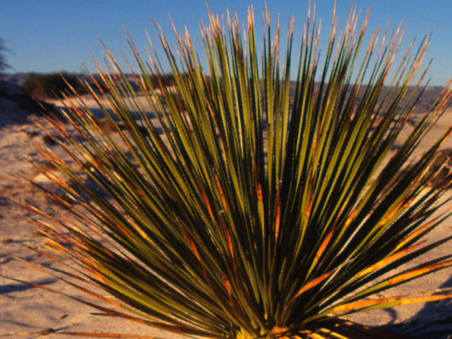
The soils often have abundant nutrients because they need only water to become very productive and have very little or no organic matter. Soils are often course textured, shallow, rocky or gravely with good drainage and no subsurface water. There is less chemical weathering the finer dust and sand particles are blown away leaving heavier pieces behind.
Monday, 30 March 2015
Wednesday, 25 March 2015
Mexico's Garbage Problem
Mexico City does not have many ways to deal with their garbage. They mainly just dump it in land fills or bury it.
Mexico City faces a lot of challenges when it comes to their trash. First, Bordo Poniente was the largest dump in Mexico City but was suddenly closed when it was on the verge of collapsing and ran a high risk of contaminating the aquifer that provides Mexico city with most of its water. Other smaller dumps fill quickly and they are now running out of options for dumping their trash. Another problem is that other states are refusing to take Mexico city's trash and now people are illegally dumping trash on the streets and is becoming a crisis. The ecology and development Center identified at least 30 failed garbage dump projects since the 1980's. The failures due to a mix of factors such as corruption and lack of political will.
I believe that Mexico will have a very hard time cleaning up their mess. I think it will help if they make more recycling return buildings so homeless people and people in poverty can collect recycling and return it so they can get a little bit of money. It would also help if people would separate their organic trash and non organic trash so their is less garbage and the compost made from the organic trash could go toward farmers with nutrient poor soil which is common in rural parts in Mexico. Teaching children what is waste and what can be recycled and what is organic compost would help teach people to be more aware about what they through away.
Thursday, 19 March 2015
Climate Impact On Mexico's Four Sphere's
Lithosphere- The Raising of temperatures will cause the soil to dry up and Mexico's deserts will spread.
- When The soil dries up the soil will turn to sand and farmers will not be able to grow crops because the soil will be infertile.
- The temperatures cause the ice up north to melt and sea levels to raise so the raising water will flood the low level coastal vegetated wetlands and Mexico will lose land mass.
- Semi desert areas will become deserts.
Hydrosphere- The raising temperatures have killed large regions of coral reef around Mexico and this effects tourism and will hurt Mexico's already struggling economy.
- The death of the carol reefs will kill off many spieces of fish that depend on the reefs for survivol and this hurts the fishing industry and tourism.
- Co2 concentration raises in the sea and kills fish in the sea including fish in Mexico.
- Water inland will dry up so rivers that farmers depend on for cattle will disappear.
- Farmers will not have enough rain fall from raising temperatures to water crops.
- The increasing heat will dry up the soil and decreasing rainfall will leave the land dry and cracked.
Atmosphere- the Increasing amount of Co2 being put in the air and traps sun rays from escaping and causes the air to get hotter.
- The hot air evaporates water from the earth leaving it drier in Mexico then before.
- Hurricanes will become more common and may kill many people as well as crops and buildings which will hurt the economy.
- Draughts will also become more in common and crops will die and farmers will struggle to keep themselves alive let alone their cattle.
- Because the soil gets drier the winds will pick up the thin dirt and sand and creat dust bowls over the desert areas and semi desert areas which could destroy Mexican crops.
Biosphere- Mexican tropical and sub tropical rain forests will dry up as the desert expands.
- Insect migrating patterns will change.
- Coral reefs die in major parts of Mexico hurting tourism.
- Fish native to the reefs in Mexico that depend on the reefs for survival will die and entire foods chains will be destroyed.
- As the concentration of co2 in the water raises fish in Mexico will die due to the lack of oxygen and this will hurt Mexican economy as well as food supplies for people.
- Animals will starve as the vegetation in the forests and semi deserts die in the heat.
- 60% of Mexican native butterflies are extinct and/or endangered.
- Higher temperatures might increase the amount of heat strokes in Mexicans in desert areas.
-As fish, animals and crops die Mexicans in rural areas will not have enough food or water to sustain themselves.
- Trees will dry up and die and people will be limited to what they can build houses with.
Thursday, 5 March 2015
Mexico Climate and Impact
Land vs. water: Inland is much dryer and hotter then on the coast. At high altitudes inland becomes cooler during December thru March. Hot wet season runs thru May to October with hottest and wettest thru June to September for most of the country. Low lying coastal areas are wetter and hotter then elevated inland ones.
Latitude: Mexico is north of the equator and the Tropic of Cancer cuts across Mexico near Mazatlán and Ciudad Victoria while south of the equator is hot and humid all year round along coastal plains on both sides.
Mountains: Mexico has a lot of mountain ranges: El Coahuilon, Sierra de la Giganta, Sierra Juarez, Sierra Juarez Oaxaca, Sierra del Lacandan, Sierra de la laguna, Los Tuxtlas, Sierra Madre Chipiasas, Sierra Madre de Oaxaca, Sierra Madre Occidental, Sierra Madre Oriental, Sierra Mixteca, Sierra Norte de Puebla, North American Cordillera, Pacific Coast Ranges, Peninsular ranges, Sierra de san Francisco, Sierra San Luis, Sierra de san Pedro Martir, Sierra Atravesada, Sierra Chichinautzin, Sierra de Los Cucapah, Sierra picachos, Sierra de san Carlos, Sierra Tamaulipas, Sierra del Burro, Tinajas Altas mountains, Trans-Mexican volcanic belt, Sierra de los Tuxtlas.
Ocean Currents: Warm N equatorial ocean currents and S equatorial ocean currents.
Pressure and Winds: the air pressure is 5860-5900 and gets easterly trade winds.
Overall Climate: Mexico in the north is arid, semi arid and temperate with dry winters. In the west it is arid and Mediterranean. The East is semi arid, temperate with dry winters and tropical wet and dry while the south is semi arid, tropical wet, humid sub tropical and temperate with dry winters. The temperatures vary from 16-45 degrees Celsius but the temperature stays almost consistant with a difference of five degrees from winter and summer. The precipitation also varys but the average per year is 780 mm.
Tuesday, 3 March 2015
Air Mass, Global Winds and Types of Rainfall in Mexico
Air masses in Mexico: In the northern parts of Mexico is the continental tropical air mass while the lower western and eastern sides have maritime tropical air mass.
Global winds: Mexico has rising warm moist air and north-easterly trade winds.
Types of rain;
Conventional rain : Occurs through out Mexico especially during summer since solar radiation and ground heating is at a maximum. This happens almost all year round in southern Mexico in the Intertropical zone.
Orographic rain fall: North-east trade winds blow moist clouds from the Gulf of Mexico towards the southern Sierra Madre and Chiapas High lands. The east side of the mountains slope in Central Veracruz, eastern Oaxaca and parts of Chiapas have 150 days of clouds and 2000 mm of rain every year. While the western slopes of the mountains have only 90 days of clouds and rain. Tenango, Oaxaca is the rainiest place in Mexico with 5000 mm per year.
Frontal rain: this only occurs in some parts of Mexico.
Monday, 2 March 2015
Mexico 1959 Hurricane
In 1959 October 23 a record breaking hurricane broke out on the west coast of Mexico. On the 23rd it started out at a category 1 the 25th it intensified to a category 4 and by the 29 the hurricane was the deadliest east pacific hurricane of a category 5. The wind speed (260 km but revisions provide evidence of the winds being higher) and landfall still hold the highest record. The hurricane also broke records on the impact and meteorological statistics. The areas most affected was Colima, Jalisco and much of western Mexico. The 1959 hurricane killed 1000 people directly with a total of 1800 lives. So many people were unprepared because they had such little warning that the hurricane was called a "sneak hurricane". It sank 3 merchant ships and two vessels. One ship 21 out of 38 hands went down and on another all hands were down. A total of 150 boats sank. one quarter of homes in Cihuatlan and Jalisco were destroyed. In Colima all coconut plantations were blown down and left thousands out of work, there the economy was already bad but after the hurricane people believed that it would take years to repair. There was a large mud slide that was 3 metres deep and killed 800 people. the mud revealed venomous scorpions and snakes that killed tens of people. Survivors were vaccinated for typhoid and tetanus and a part of Manzanillo was placed under quarantine. Air rescue operations took place but with the roads broken and covered in thick mud not much help was available. the cost of such a disaster was around 280 million. Water was undrinkable due to pollution of debris and dead bodies. Out of the five category 5 hurricanes that hit Mexico this was the only one to be on the Pacific coast.
Subscribe to:
Posts (Atom)